University of Delaware Science Summary
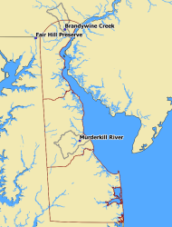
Figure 1: Location of Brandywine, Murderkill and Fair Hill watersheds in the Delaware Region. Gray lines represent watershed boundaries. Please note that the Fair Hill watershed boundary is too small to appear on this map
The DE water sensor group proposes to investigate the impacts of extreme weather (droughts and large storm events as proxies for future climate change) and land use on the exports of carbon and nutrients (nitrogen and phosphorus) from watersheds. To address these objectives, three watersheds with distinct land uses [undisturbed and predominantly forested (Fair Hill), agricultural (Murderkill), and urban (Brandywine Creek)] will be instrumented with one water quality sensor each (total three). In addition to the automated continuously-recording sensors, all sites will include routine stream water grab sampling and analysis (laboratory-based) protocols that will help calibrate as well as supplement the sensor data. The forested site is located within the Fair Hill Natural Resources Management Area in Cecil County, Maryland. The study has a nested watershed design and is part of an existing study (since 2007) funded by the NSF to investigate the fluxes, patterns, and flow paths of carbon and nitrogen for storm and base flow periods and across seasons. Hydrology of the catchments has been characterized in detail and flow paths for stream runoff have been identified using an end-member mixing model. The sources of carbon in the watersheds and their expression in stream runoff during storm events and base flow have been clearly delineated through high-frequency sampling. More recently, runoff fluxes of particulate and dissolved organic carbon for large storms associated with hurricanes Nicole (2010) and Irene (2011) have been quantified. This background understanding along with the high-frequency data collected from the NEWRnet sensors will directly help us evaluate the impacts of extreme weather and events. We will install a new sensor at the 12 ha watershed site. This will complement a similar sensor that is already planned to be installed at the 79 ha outlet as a part of our existing Critical Zone Observatory (CZO) collaboration. The Murderkill River watershed in Kent County, DE, is dominated by agricultural land use (55%), and has promulgated TMDL regulations to address non-compliance with nutrient, DO, turbidity, and bacterial standards of the Clean Water Act. In response to the TMDL directives, there are several ongoing intensive academic, state, and consultant-led research efforts on the estuarine portion of the watershed. We propose to better inform the decision making process by incorporating a high-frequency water quality sensor and associated grab sampling in the freshwater portion of the watershed to the existing array of monitoring and data distribution systems. The Murderkill watershed TMDL advisory group will provide a pool of potential participants to the agent-based modeling portion of this proposal. The Brandywine Creek study site is located within the City of Wilmington and New Castle County, DE. This site will represent our "urban" watershed end-member. The sensor will be deployed in the Brandywine Creek adjacent to the intake of the Porter filtration and drinking water supply plant for the City of Wilmington for direct application to city drinking water quality.