Watershed study treads new ground
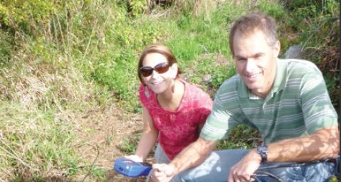
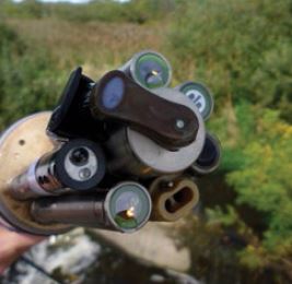
URI hydrologist Kelly Addy and Salve Regina University ecologist Dr. Jameson Chace test a water sensor (inset photo) in advance of setting up the system for the Track-2 research project.
Watershed study treads new ground
Latest sensor technology tracks data, gives in-depth look
By Amy Dunkle
Placed in Rhode Island watersheds early this summer, three state-of-the-art sensors are taking the pulse of freshwater resources in the Ocean State.
Researchers deployed the sensors in three streams, one in Scituate and two in Middletown. Each stream drains watersheds surrounded by differing land use — forested, agricultural and urban — yet, are similar in terms of size, soils and geology.
“Traditionally, the method for studying river water quality consists of collecting water samples periodically, like once per month or season,” said Kelly Addy, a University of Rhode Island hydrologist. “This approach can miss many trends that occur in short timeframes as well as the impact of weather events.”
The sensors measure such parameters as water depth, temperature, dissolved oxygen and organic matter, nutrients, and cloudiness. They record the information every 15 minutes and transmit the data via cellular network with almost instantaneous Internet accessibility.
In addition, automatic water sampling equipment at each site is triggered to collect water samples every 30 minutes throughout the course of a storm or during some other period of interest thereby allowing the analysis of additional contaminants.
Addy said, “The ultimate goal of the project is to provide immediate and valuable information so that the state and local communities can make timely decisions and enact policies to best preserve and protect our water quality.”
As part of the North East Water Resources Network (NEWRnet) partnership, Delaware and Vermont researchers are placing the same equipment in similar types of streams to provide a comprehensive regional picture of how climate variations may play a role in water quality and quantity during weather events.
With three states of varying local climates, precipitation, and population density collecting data, the information compiled will present a unique and valuable perspective.
Geographically, researchers can view the project in terms of the north-south corridor of Vermont-Rhode Island-Delaware. From north to south, there is a progression from colder to warmer climate as well as from lower to higher populations.
Addy said the commonality in the equipment design and these varying features would allow researchers to tease out data trends to fill in unknowns and provide a more complete picture of what is taking place locally, statewide and throughout the northeastern corridor. Project results will give local and state officials the insight and tools they need to make better land use decisions.
What the sensors tell us
Monitoring the Rhode Island watersheds involves two different types of sensors, one of which will track general parameters, such as temperature and pH. The second sensor records nitrate-nitrogen measurements. Nitrogen is particularly important to coastal waters.
Classic sources of nitrogen include fertilizers, whether agricultural or home use, and septic systems. Excess nitrate flowing into coastal waters can trigger algal blooms, a decline in dissolved oxygen, fish kills, and the decline of beneficial aquatic eelgrasses that can support shellfish communities.
Some algal blooms release toxins that can be harmful to humans and wildlife.
The obvious question is, if there is concern about nitrate in coastal waters, why place the sensors upstream in watersheds?
“It can seem like a little bit of a disconnection,” Addy said. “But, it is the practices within a watershed that can generate excess nitrate. Wetlands and streams can serve as filters for nitrate, but if these systems are overloaded, the nitrate will continue through the stream network and ultimately end up in coastal waters – for us, that is Narragansett Bay and coastal ponds along the south shore of Rhode Island.”
The sensor selected for the project detects and records information as a small beam of light passes through the water within a pathway on the sensor, giving researchers a full spectrum of data to consider. The continuous recording of data also will determine any daily pulses in water quality parameters as well as provide an in-depth look at events, such as large storms or low flows that are extremely difficult to assess without such equipment.
Addy noted that the Scituate and Middletown streams of study also contribute water to public drinking water systems. These real-time sensors can be extremely helpful in detecting changes in parameters that may increase human health risks.
For example, high levels of organic matter being released into streams as a result of a major storm event could react with the chlorine used in water treatment facilities to generate trihalomethanes, which have been found to be harmful to humans. If the sensors detect organic matter levels above a certain threshold, the water managers could make adjustments necessary to prevent this hazard.