Proposed Rhode Island Sensor Network
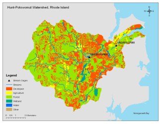
The RI water sensor team will instrument a total of five locations within two watersheds that drain directly in Narragansett Bay to examine relationships among land use, climate and water quality. Sensor deployment will be combined with geospatial analyses and stream assessment studies to address questions are emblematic of watershed challenges confronting decision makers, specifically, establishing guidelines for low flow thresholds, storm water management and wetland protection. A nested sampling scheme will be used for sensor deployment within the Hunt River watershed (drainage area approximately 59 km2). This unsewered watershed is composed of a mix of residential, agricultural and forest land use. The river flows directly into the Potowomut estuary of Narragansett Bay. The Hunt River watershed has been the site of numerous, published studies by URI scientists on stream and riparian nutrient cycling. A TMDL study implicated the river discharge as the primary cause of shellfish closure in the adjacent estuary, with marked declines in water quality during storm events. The river also has been under scrutiny for extreme low flows. This nested sampling scheme will foster mass-balance studies that will serve as a basis for process level investigations of potential transformation pathways at different seasons and flow regimes across different land uses. We will also deploy a sensor array at Bailey Brook, a small (7 km2) urbanized watershed on Aquidneck Island that drains to the primary drinking water reservoir of Newport, RI. This water supply is plagued by a number of water quality issues, including cyanobacteria blooms. The hydrology of this watershed is dominated by storm runoff, but a number of storm water control measures have been implemented. Salve Regina University has conducted stream monitoring on this watershed over the past three years.